What OS NGD means for enterprise location intelligence


In March 2026, Ordnance Survey announced that the OS National Geographic Database held 16 data collections and 70 major enhancements, making it the most detailed digital map of Great Britain ever created. Three and a half years after its launch, the OS NGD has evolved from an ambitious vision into an operational reality, with over half a billion geographical features and up to 30,000 daily updates. To date, there have been more than 1.4 million transactions on the NGD Features API.
For enterprises that rely on OS data for asset management, infrastructure planning or customer insight, this is the clearest signal yet that the legacy OS Master Map era is drawing to a close – and that your data strategy needs to move with it. Legacy products are being retired on a published timeline. New capabilities are landing exclusively in the NGD. And the gap between what legacy products offer and what the NGD delivers is widening with every quarterly release.
This article breaks down what’s changed, what’s coming next, and what your engineering and GIS teams should be thinking about right now.
What changed in the spring 2026 release
Several of the new datasets unlock analytical capabilities that simply didn’t exist before – and they’re worth understanding in some detail. The Spring 2026 release brought full GB coverage of bus and cycle lanes, completing a rollout that had been building iteratively since September 2025. For councils and transport planners working on Active Travel strategies, this means authoritative infrastructure data is now available nationally. When combined with the NGD’s existing Routing and Asset Management Information collection, it provides a comprehensive picture of road network characteristics that routing engines and planning tools can consume directly.
Perhaps the most significant addition for address-dependent workflows is the new Royal Mail Address Feature Type. For the first time, full PAF content has been combined with Ordnance Survey’s authoritative geospatial attribution in a single feature type. If your systems currently pull PAF from one source and spatial referencing from another, this convergence could simplify your data architecture considerably. A new functional areas collection has introduced algorithmically derived retail area boundaries – at major, minor and aggregated levels – giving a nationally consistent, data-driven view of retail geography across GB. For site selection, catchment analysis or planning applications, this is a layer that previously required expensive proprietary datasets or manual delineation.
New building-level attributes are also worth noting – roof shape, roof aspect and green roof presence. These open practical analytical possibilities in solar energy yield modelling, urban greening assessments and sustainability reporting, areas where granular building data has historically been a bottleneck. And there are the building access location features, identifying vehicle and pedestrian access points to key public buildings. For emergency response planning and accessibility auditing, this kind of precision matters.
What’s being retired, and why it matters now
The expansion of the NGD only tells half the story. The other half is the systematic retirement of legacy products, and this process has already begun. The OS MasterMap Water Network Layer reached its end of life on 31 March 2026. From that date onwards, Ordnance Survey will cease to publish updates and remove access to the OS Data Hub and APIs. Although existing data packages will remain available for up to 12 months, the data itself will no longer be maintained. If your flood modelling, drainage analysis or environmental monitoring workflows still depend on it, you will now be working with a static dataset in a world that updates daily.
The most widely used product in the OS portfolio, the MasterMap Topography Layer (first launched in 2001), is next. Its successor, OS BaseMap Pro, is currently in its prototype phase and is scheduled for a full launch in 2027. BaseMap Pro will provide the detailed, reliable basemap that organisations have relied on for over two decades in a format designed for modern applications and built to work alongside OS NGD analytical data. Waiting until the final retirement date to begin migration will mean trying to complete a significant technical transition in a very short timeframe.
AddressBase, AddressBase Plus and AddressBase Plus Islands are scheduled to reach the end of their lifecycle in November 2027. Any organisation that has built data pipelines, reporting tools or customer-facing applications around these schemas should start planning the transition now, rather than waiting until the deadline is only twelve months away. OS Highways Network with Speed Data was withdrawn in March 2024, and its replacement data is available in the NGD Transport Theme. Average speeds and indicative speed limits can now be accessed directly from the NGD, providing richer attribution and more frequent updates.
The NGD is becoming the single source and legacy products are being retired. OS is providing migration documentation, code examples and consultancy support through the PSGA, but adapting your systems is your responsibility.
See our geospatial offerings!
Find out more
How to access OS NGD data
Understanding what’s in the NGD is one thing. Connecting your systems to it is another. Here’s what the access architecture looks like in practice. OS NGD data can be accessed in two main ways:
- OS Select+ Build is a configurable download service that allows you to specify exactly what you need by theme, feature type, attribute filter and schema version, and then retrieve the data in GeoPackage or CSV format. This option is well suited to periodic bulk extracts, analytical workloads and offline processing.
- For real-time or on-demand integration, the OS NGD API-Features delivers data in GeoJSON format, while the OS NGD API-Tiles provides vector tiles for interactive web mapping applications. If you are building customer-facing map interfaces or operational dashboards, the Tiles API provides a detailed, customisable basemap that is powered directly by the NGD.
- One of the less discussed but practically significant changes is the update cadence. The NGD now updates daily, a fundamental shift from the six-weekly cycle that most Master Map users have been accustomed to for years. For operational use cases such as field workforce routing, emergency response or network planning, this represents a significant improvement in data currency.
Since June 2025, Select+ Build has supported recipe editing. Now, you are able to add or remove themes, adjust attribute filters, and switch data schema versions without having to rebuild your configuration from scratch. For teams managing multiple data extracts across departments, which, in large organisations, often equates to dozens of separate configurations , this eliminates a significant operational bottleneck.
Access is available through the PSGA for public sector organisations, and through the Premium Plan on the OS Data Hub for commercial users. Since its launch, over 390 organisations have used Select+ Build, but many enterprises are still in the early stages of migrating from legacy access patterns.
What this means for your sector
Utilities
Utility companies face a particularly pressing timeline. NUAR (the National Underground Asset Register), which runs on OS infrastructure, already requires harmonised, frequently updated spatial data from asset owners. The NGD’s daily refresh cycle, enriched building and structure data, and new access point features directly support the kind of asset-to-address matching and spatial referencing demanded by NUAR compliance.
As statutory obligations tighten and NUAR expands its coverage, utilities still working with six-weekly Master Map updates risk falling behind regulatory expectations and their own operational needs.
Transport & logistics
Full bus and cycle lane coverage, combined with the RAMI collection’s routing attributes, speed data and network restrictions, provides transport planners and fleet operators with an authoritative baseline that no longer requires supplementation with manual surveys or the purchase of third-party data.
For enterprises operating routing engines, fleet management platforms or mobility-as-a-service applications, the practical question shifts from ‘Can we access the data?’, to ‘Can our systems process it at the frequency with which the NGD now delivers it?’ While daily updates to the national road network dataset are valuable, they are only useful if your architecture can ingest and propagate them without manual intervention.
Land & property
The new retail areas dataset and improved postcode geography provide new opportunities for analysis in areas such as site selection, catchment analysis, planning applications and market research. When overlaid with the NGD’s building-level attributes such as age, construction materials, roof characteristics and access points, an analysis of land or property that previously required data to be assembled from multiple OS products now sits in a single, queryable source.
For property technology platforms and real estate analytics firms, this consolidation reduces licensing complexity and data integration costs.
Environment & sustainability
Green roof presence, enhanced land use classification and tighter integration with agricultural land management workflows make the NGD increasingly relevant for sustainability reporting under frameworks such as CSRD, TNFD and England’s Biodiversity Net Gain requirements.
OS has recently worked with Scotland’s Rural Payments and Inspections Division to develop models using NGD data that automate the detection of land parcel changes – replacing manual checking of hundreds of thousands of records.
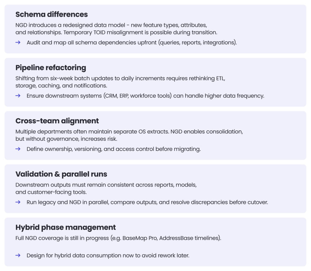
The practical challenges of migration
Moving from legacy OS products to the NGD isn’t simply a matter of swapping one data source for another. There are real technical and organisational challenges that are worth acknowledging.
Over to you
At Spyrosoft, we have been working alongside Ordnance Survey for several years, developing systems at the core of their data infrastructure. Our teams have delivered the SOR platform, OS’s centralised hub for managing all geospatial data, as well as key components of the NUAR application, the custom-made map printing platform and the machine learning models that power route quality predictions in OS Maps.
This hands-on experience has given us a practical understanding of what the NGD transition involves, both technically and organisationally. We have familiarised ourselves with the data model. We understand the integration patterns. We also know where common sticking points tend to appear.
If your team is planning an OS NGD migration or trying to understand the potential of the new datasets for your sector, we would be happy to share our knowledge – get in touch with our geospatial team by filling in the form below.
The Ordnance Survey National Geographic Database is the most comprehensive digital representation of Great Britain ever created. It contains over half a billion geographical features and receives up to 30,000 daily updates. Unlike legacy OS products, the NGD unites authoritative geospatial data, analytics-ready structures, and API-first delivery within a single ecosystem. This gives enterprises access to more current, richer and better-connected location intelligence for operational, analytical and customer-facing applications. As legacy products are gradually retired, the NGD is establishing itself as the UK’s primary source of authoritative geospatial data.
Several long-standing OS products are reaching end-of-life milestones, including the OS MasterMap Water Network Layer, with future retirements expected for AddressBase and the MasterMap Topography Layer. Organisations that delay migration risk becoming dependent on static datasets that no longer receive updates, while new functionality continues to be developed only within the NGD ecosystem. Migrating involves more than just swapping data – it often requires schema redesign, pipeline adjustments, and integration testing across multiple systems. Starting the process early gives engineering and GIS teams time to validate outputs, modernise architectures, and avoid having to rush close to retirement deadlines.
The Spring 2026 release introduced several datasets that significantly expand the scope for analysis across industries. These include nationwide bus and cycle lane coverage for transport planning, retail area boundaries for site selection analysis, and building-level attributes such as roof shape, the presence of green roofs, and access points. Integrating Royal Mail PAF data with Ordnance Survey spatial attribution also simplifies address-centric workflows that previously required multiple data sources. Together, these additions enable more advanced geospatial analysis and better operational decision-making, while reducing data integration complexity.
One of the biggest challenges is adapting systems that were built around six-week update cycles so that they can handle daily incremental data refreshes. Enterprises often need to refactor ETL pipelines and redesign caching strategies, as well as ensuring that downstream systems can process much more frequent updates. The NGD also introduces a redesigned schema with new feature relationships and attributes, meaning that reports, integrations and applications may require extensive remapping and testing. Additionally, many organisations will need governance processes to manage hybrid environments where legacy products and NGD datasets coexist during the transition period.


arrow_circle_rightcontact us
Let’s get in touch to check how our experts could support your project

arrow_circle_right our blog