Proactive risk management in logistics with geospatial analytics


In a globally interconnected supply chain, logistics operations face an unprecedented range of risks. As companies strive to increase resilience and ensure uninterrupted service, reactive risk management strategies are no longer sufficient. To stay competitive and mitigate losses, logistics leaders must shift toward a proactive, data-driven approach to identifying and addressing vulnerabilities before they escalate.
In this context, geospatial analytics can play a game-changing role. By integrating location intelligence with real-time operational data, geospatial analytics provides actionable insights into risk exposure across the entire logistics network. From tracking fleet movement in real-time to forecasting delays caused by natural disasters or urban congestion, geospatial tools enable organisations to anticipate disruptions, optimise decision-making, and safeguard supply chain continuity.
In this article, we’ll explore how geospatial analytics can support logistics teams to manage risk proactively.
The importance of assessing environmental risk
An environmental risk assessment is a critical component of modern logistics and supply chain management, especially given the increasing frequency and severity of climate-related disruptions. Transport networks, distribution centres, and storage facilities are becoming increasingly vulnerable to natural disasters such as floods, wildfires, hurricanes, and extreme weather conditions. These events can cause significant operational disruptions, endanger safety, and lead to increased costs.
Proactively identifying and evaluating these environmental risks enables organisations to strengthen their operational resilience by implementing mitigation strategies before any disruption occurs. This may involve selecting alternative transport corridors, redesigning delivery schedules or reconfiguring warehouse locations to avoid high-risk areas. Furthermore, an environmental risk assessment helps organisations comply with regulatory requirements, such as climate disclosure frameworks and sustainability standards, while also aligning with broader environmental, social and governance (ESG) objectives.
From a financial standpoint, assessing environmental risk reduces exposure to insurance claims, liability and reputational damage by enabling data-driven, informed decision-making. As environmental volatility becomes a defining challenge in global logistics, integrating risk assessment into strategic and operational planning is essential for maintaining continuity, protecting assets, and ensuring long-term competitiveness.
The part that geospatial analytics play in risk management
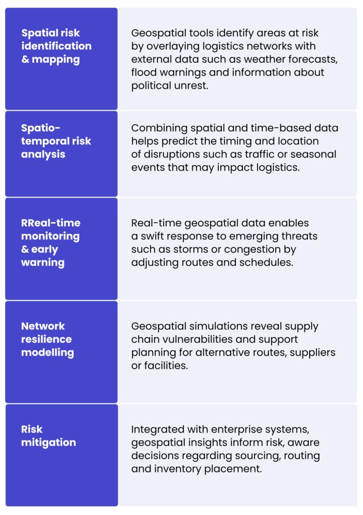
Geospatial analytics are enhancing the risk management capabilities of the logistics sector by incorporating a spatial dimension into the identification, analysis, and mitigation of potential threats. At its core, it enables businesses to understand where risks lie, mapping the spatial distribution of vulnerabilities, disruptions and dependencies across the supply chain. With geolocation context businesses are able to identify patterns, model impact zones and execute timely, localised responses.
Key benefits and applications of geospatial analytics in logistics
- Route optimisation – Analysing geographic data helps determine the most efficient and least risky transportation routes, thereby improving delivery times and reducing fuel consumption.
- Facility location planning – Geospatial analytics assists in selecting optimal locations for warehouses and distribution centres by evaluating factors such as proximity to markets, transport networks and environmental risks.
- Inventory management – Spatial analysis supports better inventory placement and movement strategies by providing insight into regional demand patterns and potential supply chain disruptions.
- Real-time monitoring – Implementing geospatial tools enables the real-time tracking of assets and shipments, thereby enhancing visibility and responsiveness to unforeseen events.
- Disaster recovery & response – In the event of natural disasters, geospatial analytics facilitate a rapid assessment and response by identifying affected areas and optimising relief logistics.
- Compliance with government, state or local restrictions – Geo analytics ensures operations align with regulations by mapping routes, facilities, and activities against legal and environmental boundaries.
Technologies enabling proactive risk management in logistics
Data collection & preprocessing
Geospatial analytics relies on vast and diverse data sources like GPS signals, IoT sensors, satellite imagery, weather feeds, traffic data, and even social media. These sources often vary in format, structure, and frequency, creating significant challenges in harmonisation. Preprocessing involves cleansing noisy data, correcting spatial inaccuracies, converting timestamps, and integrating structured (e.g., tabular delivery data) and unstructured inputs (e.g., image or textual alerts). Robust ETL (Extract, Transform, Load) pipelines and geospatial data wrangling techniques are essential for ensuring reliable downstream analytics.
Geospatial data formats & standards
To maintain interoperability and consistency across systems, geospatial data must conform to recognised formats and standards:
- Vector formats like KML, MVT, GeoJSON and shapefiles represent features such as roads, warehouse locations, or delivery zones with points, lines, and polygons.
- Raster formats are used for satellite imagery, weather maps, or elevation models, representing data as pixel grids (e.g., GeoTIFF).
- Standards defined by organisations like the Open Geospatial Consortium (OGC) ensure seamless data exchange between systems.
Choosing the right format is crucial and depending on the type of analysis, raster is typically used for environmental layers, while vector is preferred for tasks like routing or zoning. However, depending on the use case, data may need to be converted between formats, for example, extracting vector features from raster imagery or rasterising vector data for spatial modelling.
Modelling techniques
Advanced modelling techniques are at the heart of risk forecasting and scenario simulation:
- Spatial clustering (e.g., DBSCAN) detects hotspots of recurring incidents like delivery thefts or delays.
- Spatio-temporal analysis helps identify patterns that evolve over space and time, such as traffic bottlenecks during specific hours or seasonal flood zones.
Geospatial machine learning, including methods like kriging (used for spatial interpolation) and hot spot detection, enables predictive insights, for example, estimating risk levels in unmonitored areas or predicting where disruptions are likely to occur next.
Integration with existing logistics systems
To deliver real operational value, geospatial analytics must integrate smoothly with core logistics platforms:
- Transportation Management Systems (TMS) for route optimisation and dispatch planning.
- Enterprise Resource Planning (ERP) systems for inventory, procurement, and financial risk implications.
- Warehouse Management Systems (WMS) for facility operations and capacity planning.
APIs, middleware and spatial databases (e.g. PostGIS and BigQuery GIS) facilitate this integration by enabling a seamless flow of data and providing actionable insights within familiar operational workflows. Furthermore, analytics engines with spatial support, such as Spark combined with Sedona, facilitate the scalable processing of substantial geospatial datasets, thereby augmenting the system’s capacity for complex spatial analysis.
Security & privacy in geospatial data usage
Geospatial data, especially when it involves fleet locations, customer addresses, or strategic assets is highly sensitive. Ensuring data security and privacy is paramount:
- Access controls, encryption (at rest and in transit), and audit logs must be enforced.
- For personally identifiable location data, compliance with regulations such as GDPR or CCPA is essential.
- In distributed analytics environments (e.g., cloud-edge architectures), securing data across multiple nodes requires robust cybersecurity protocols.
Organisations must also establish clear data governance policies to manage geospatial datasets responsibly.
Challenges & limitation
Although geospatial analytics shows great potential for improving risk awareness and operational resilience in logistics, there are challenges associated with its implementation. These limitations span technical, organisational and data-related areas and must be carefully addressed to maximise the benefits of location intelligence.
Data availability & quality issues
Effective geospatial analysis relies heavily on access to accurate, up-to-date and high-resolution spatial data. However, logistics operations often involve diverse geographies and jurisdictions where consistent data quality cannot be guaranteed.
- Sparse or outdated datasets in remote or developing regions.
- Lack of standardised data formats across suppliers, carriers and regions, which complicates integration.
- Inconsistent data granularity, which can skew analytical outcomes when combining global, regional and hyperlocal layers.
The complexity of data integration
To deliver actionable insights, geospatial analytics must integrate spatial data with operational data from various enterprise systems. However:
- Heterogeneous data sources often lack interoperability.
- Legacy logistics systems may not support real-time data ingestion or geospatial formats (e.g. GeoJSON or shapefiles).
- Siloed IT architectures hinder the seamless flow of contextual spatial information across departments.
- Geospatial datasets are tied to specific coordinate reference systems (CRSs). With hundreds of horizontal and vertical datums in use, it can be difficult to unify data under a common reference, especially when reference definitions are missing or inconsistent.
This complexity increases the need for robust data pipelines, APIs and middleware that can unify spatial and non-spatial datasets.
Technical expertise & resource constraints
Deploying and maintaining a geospatial analytics solution requires specialist skillsets that are not always available within traditional logistics teams.
- GIS specialists, data scientists with spatial modelling expertise and DevOps professionals who are familiar with geospatial data pipelines are in short supply.
- Interpreting spatial outputs requires domain knowledge to avoid making misinformed decisions, for example, misjudging the impact radius of a flood zone.
- Processing is resource-intensive, especially for real-time or high-resolution spatial computations, and may require advanced infrastructure or cloud computing capabilities.
Limitations of models & analytical tools
Geospatial modelling techniques have certain inherent constraints:
- Predictive accuracy can degrade in volatile or rapidly changing environments (e.g., conflict zones, regions with unpredictable weather patterns).
- Static models may fail to capture dynamic interactions such as multi-modal transport behaviour under disruption.
- Spatio-temporal models are more accurate but significantly more complex, requiring larger datasets, fine-tuned parameters, and longer development cycles.
Additionally, if historical data reflects only past ‘normal’ conditions, model bias can emerge, rendering the models less effective in anticipating novel threats.
Privacy, compliance and ethical concerns
Using location-based data can present potential legal and ethical challenges.
- Regulations such as the GDPR and CCPA restrict how geospatial data can be collected, processed and stored, especially when it is linked to individuals or sensitive operations.
- If not transparently communicated and consented to, geofencing and real-time tracking may raise concerns among employees, subcontractors, or customers.
- Data anonymisation and encryption techniques add layers of complexity to system design and performance tuning.
By partnering with us, you can make the most of geospatial analytics without encountering the usual obstacles. With our support, you will avoid fragmented data, interoperability issues, skills shortages and compliance risks, setting your organisation up for resilient, insight-driven logistics operations.
Data integration pipelines for drone delivery services
For one of our clients, a pioneering American company developing drones and systems for e-commerce delivery, we built a new, scalable data platform to support their rapid growth. Their technology integrates with external systems like LAANC (Low Altitude Authorisation and Notification Capability) to plan drone routes based on factors such as population density, weather, and accident risk.
The client’s original solution, based on periodic scripts, was no longer sufficient. To meet evolving needs, we redesigned their data platform to enable real-time and batch processing, data archiving, and future-proof reporting. We ensured a smooth transition by maintaining the legacy system during the build phase and began with a thorough analysis of existing integrations.
The result is a reliable, high-performing platform that integrates seamlessly with external systems, enhances flight planning accuracy, ensures regulatory compliance, and supports the client’s ongoing expansion with minimal downtime.
Conclusion
As the logistics becomes increasingly complex and prone to risk, reactive strategies are no longer sufficient to ensure operational continuity. Geospatial analytics offers a powerful, proactive approach to risk management, providing location-based insights from real-time and historical data. It enables organisations to respond faster, smarter and more strategically, from optimising routes and mitigating environmental threats to forecasting supply chain disruptions.
Partner with us for consistent business value
If you think that the time is right for your company to become a market leader and corporate geospatial intelligence as a core component of your risk management strategy, fill up the form and contact our experts!


It adds spatial context to risk data. Instead of knowing that a disruption exists, you know where it is, how it relates to your routes, facilities, and inventory, and what is likely to be affected. That context is what allows logistics teams to act before a disruption hits rather than responding after the fact. Applications include route optimisation, facility location planning, real-time shipment tracking, and rapid disaster response.
Environmental threats such as floods, wildfires, and storms can be mapped against logistics networks in real time. When a weather event is forecast, the system can identify which routes and facilities fall within the affected area and model alternatives. Over time, historical data supports longer-term decisions such as moving facilities away from high-risk zones or redesigning supply chain networks to reduce exposure.
The foundation is a combination of GPS feeds, IoT sensors, satellite imagery, weather data, and traffic information. These need to be standardised into common formats and fed into analytics engines capable of spatial processing at scale. Integration with existing systems such as Transport Management Systems, ERP, and Warehouse Management Systems is also necessary for the insights to be actionable.
Data quality is a consistent issue, particularly in remote regions where coverage is sparse or inconsistent across suppliers. Legacy systems often lack support for geospatial formats, making integration technically complex. There is also a shortage of specialists with combined GIS and data engineering skills. On the analytical side, predictive models trained on historical data can underperform in genuinely volatile or novel conditions.
Yes. GDPR and CCPA place restrictions on how location data relating to employees and customers can be collected, stored, and used. Geofencing and tracking practices need to be transparent, and data anonymisation and encryption add complexity to system design. Organisations should build data governance policies and access controls into the architecture from the outset rather than retrofitting them later.
arrow_circle_rightcontact us
Let’s get in touch to check how our experts could support your project

arrow_circle_right Our articles