GeoAI in identifying environmental risks and mitigation strategies


Traditional geospatial analysis methods, while valuable, often lack the granularity, scalability and predictive capabilities required to address the complex dynamics of pollution patterns in real time.
GeoAI refers to the solutions where artificial intelligence techniques and technologies meet geospatial data and analytics. In this article, we introduce the sophisticated role of this advanced technology in pollution detection and mitigation. We also illustrate these concepts with a case study involving one of our clients.
Leveraging GeoAI for proactive environmental management & business advantage
GeoAI is revolutionising environmental management by combining high-resolution satellite imagery, real-time IoT sensor data, and historical environmental records to accurately detect, predict, and monitor patterns. This fusion of disparate data sources, analysed using advanced computer vision models, spatio-temporal analysis and deep learning algorithms, enables organisations to move from reactive responses to proactive, data-driven mitigation strategies. Rather than simply dealing with environmental issues after they occur, organisations can now anticipate problems and take early action, reducing long-term risks and costs.
For technology leaders, the impact of GeoAI goes far beyond environmental compliance. With the ability to pinpoint risks’ sources, model the spread of contaminants and simulate the results of potential interventions, companies gain a significant competitive advantage. These capabilities enable them to achieve compliance more cost-effectively, streamline resource use and strengthen corporate sustainability initiatives. The use of GeoAI contributes to a cleaner environment and drives smarter business decisions, aligning environmental responsibility with operational efficiency and long-term growth.
Environmental risk identification
Air & water pollution hotspot detection
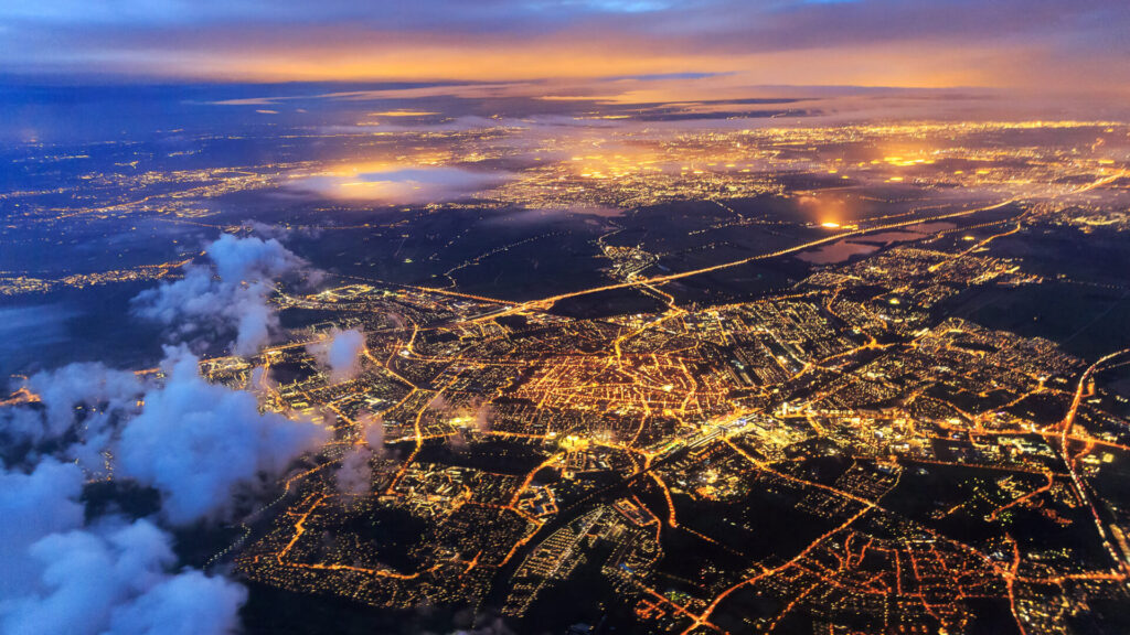
Air and water pollution pose a serious threat to human health, quality of life and the balance of ecosystems. GeoAI, which combines the analysis of satellite imagery with real-time data from sensor networks, enables the precise detection of pollution hotspots. Advanced AI models identify patterns in the spread of pollutants, track changes over time and predict pollution trajectories, considering factors such as wind direction, industrial activity and urban traffic. This allows decision-makers to take quick and effective action to prevent further pollution.
For one of our clients, MicroBubbles GmbH – a pioneering venture supported by Germany’s SPRIND – we were asked to conduct research into the concentration of microplastics in Germany’s inland surface waters and provide a digital tool for geospatial analysis.
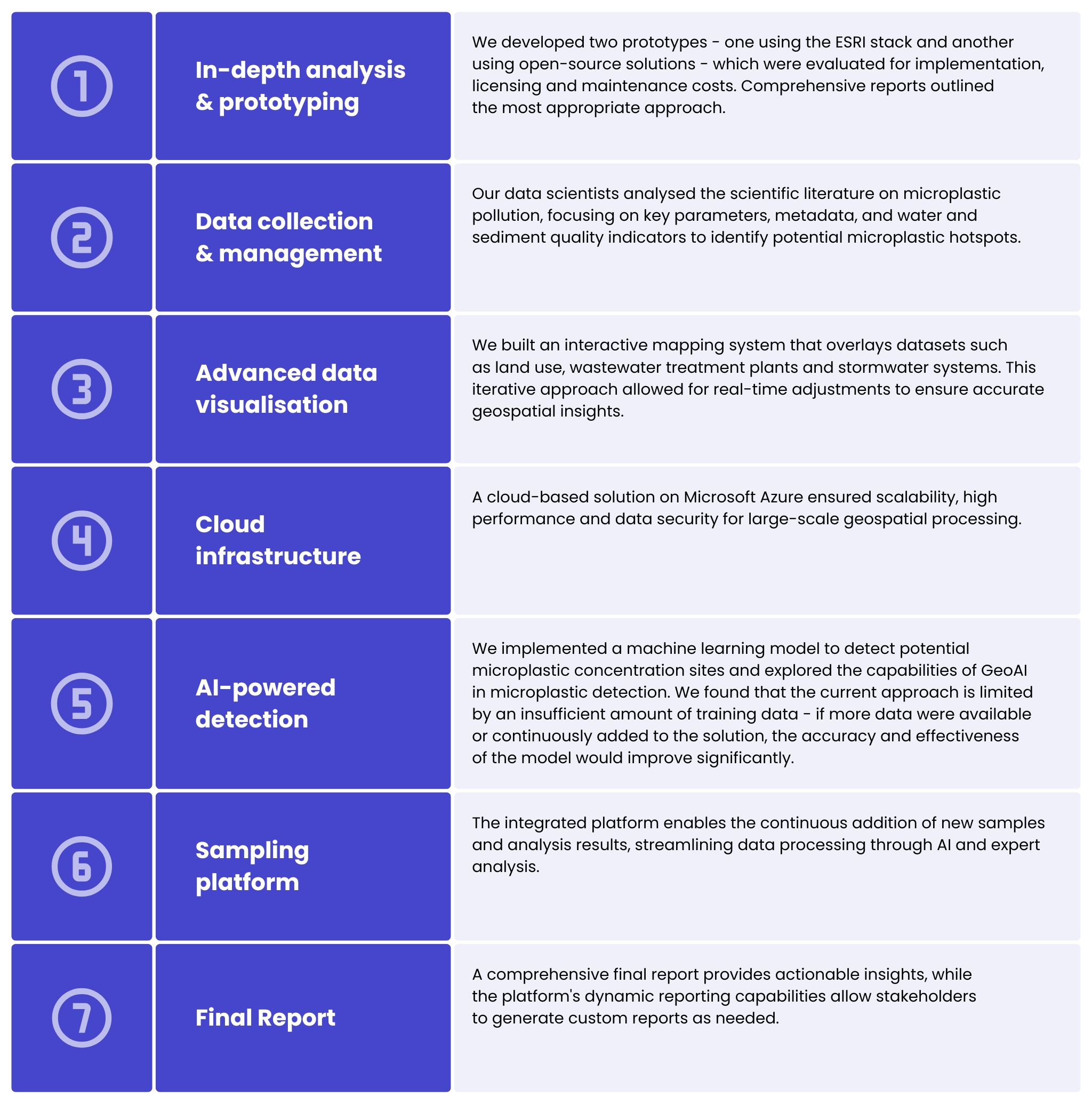
The system developed enables MicroBubbles GmbH to identify microplastic hotspots and predict future areas of contamination, supporting long-term environmental strategies. Future enhancements may include advanced visualisation features and the integration of additional data sets, such as traffic data.
Deforestation & land degradation
Deforestation and land degradation lead to biodiversity loss, accelerate climate change and destabilise local economies. Remote sensing technologies, satellite imagery and earth observation (EO) data allow accurate monitoring of changes in forest cover over time. AI-based systems process EO data to generate early warnings of illegal logging, detect unsustainable land use patterns, and assess vegetation health. AI is also analysing habitat changes, identifying threatened ecosystems and monitoring biodiversity trends by integrating EO data with climate models and geospatial analysis. These insights help governments and organisations develop effective conservation strategies, prioritise reforestation projects, and protect endangered species by targeting resources where they are most needed.
Urban environmental challenges
The rapid growth of cities is associated with many environmental challenges, such as urban heat islands, increased flood risk and infrastructure congestion. GeoAI analyses spatial data on land use, infrastructure layout and population density to support urban planning. It includes the ability to detect urban heat islands by correlating temperature data with vegetation cover, surface materials and building density. The results of the analysis guide city planners on where to implement cooling solutions, such as green roofs or urban forests. In addition, GeoAI assesses flood risk by analysing elevation data, drainage systems and historical flood patterns, enabling infrastructure designs that minimise risk and support sustainable urban development.
Climate change & extreme weather events
The increasing frequency and intensity of extreme weather events such as hurricanes, floods and droughts are a direct result of climate change. Machine learning models simulate potential climate scenarios, helping to assess the likelihood and impact of upcoming events. In addition, GeoAI supports emergency planning by identifying the most vulnerable regions, optimising evacuation routes and simulating emergency scenarios, promoting more efficient resource allocation and minimising human and economic losses.
For Rebalance Earth, a UK startup that funds environmental and climate resilience projects, we supported a map-based web application development to visualise flood and drought risk.
The tool helps to present different scenarios and economic assessments of environmental projects, making a compelling case for investors to fund these initiatives.
Using geospatial data and hydrological modelling, it enables in-depth analysis and demonstrates the potential benefits of mitigation measures. Rebalance Earth secures funding from pension funds, local businesses and local governments for initiatives such as deepening riverbeds, strengthening dikes and improving water quality.
When we took on the project, the application was in need of:
- optimisation & stabilisation: fixed UI/UX issues and refined code for better usability and stability.
- infrastructure modernisation: enhancing deployment pipelines and improving security.
- new features: added datasets and analytical models for more accurate risk visualisation.
The app is now evolving into a powerful tool that supports sustainable investment and natural resource conservation, contributing to more effective climate risk management for future generations.
Discover our geospatial offerings!
Learn more
Advanced techniques for environmental hotspot detection
Enviromental risk identification requires dynamic, scalable and intelligent systems capable of processing large, heterogeneous data sets. Geospatial AI is impacting this type of detection landscape by combining machine learning, computer vision, and big data processing with advanced methods to deliver automated, highly accurate insights previously unattainable with traditional approaches.
By leveraging machine learning algorithms, such as convolutional neural networks (CNN) for image classification and recurrent neural networks (RNN) for time series forecasting, GeoAI can automatically identify subtle patterns that indicate potential sources of pollution.
Computer vision techniques further enable the precise analysis of satellite and aerial imagery to detect unauthorised emissions, algal blooms, or deforestation with minimal human intervention. However, the greatest advantage of GeoAI lies in its ability to perform real-time data fusion. These systems integrate information from high-resolution satellite imagery, IoT sensor networks monitoring air, water, and soil quality, urban mobility data, and meteorological forecasts. This synchronisation allows the creation of holistic environmental models that detect anomalies in real time, such as correlating sudden spikes in PM2.5 concentrations with specific weather conditions or industrial activities. Additionally, unsupervised learning techniques, including DBSCAN and K-means clustering algorithms, enable the identification of unexpected events without the need for predefined labels. Crucially, GeoAI monitors and predicts future environmental risks by employing predictive modelling techniques, like long short-term memory (LSTM) networks and gradient boosting machines (GBM). Combined with geospatial intelligence, this enables prediction of pollution dispersion patterns, simulation of the impact of urban development on air and water quality, and identification of high-risk communities.
The integration of remote sensing data, IoT telemetry, and advanced AI models into a unified GeoAI platform represents a shift in environmental risk management, providing organisations with real-time situational awareness and strategic foresight to enable proactive mitigation efforts.
Mitigation strategy examples based on GeoAI insights
GeoAI’s ability to deliver real-time geospatial intelligence, predictive analytics and automated anomaly detection enables organisations to develop and implement targeted, data-driven mitigation strategies. These insights enable organisations to proactively respond to environmental risks, optimise operations, and integrate sustainable practices across industries.
Scenario-based planning
Utilises GeoAI-powered what-if simulations based on geospatial digital twins, using Bayesian networks and reinforcement learning to model the environmental impact of different mitigation strategies. These simulations enable organisations to dynamically compare cost-effective and sustainable approaches. Urban planners can use land use classification models applied to satellite imagery and LiDAR data to predict the long-term environmental impact of infrastructure projects and ensure sustainable urban development.
Early warning & response systems
Implements real-time anomaly detection using RNNs and LSTM models on time-series pollution data, enabling proactive risk mitigation. AI-driven sensor fusion aggregates data from IoT-enabled air and water quality monitors, generating predictive alerts that minimise environmental damage. All of this contributes to resilient emergency response frameworks that ensure minimal operational disruption during pollution incidents.
Traffic management
Uses spatio-temporal AI models, including graph-based deep learning, to dynamically detect pollution hotspots and adjust urban mobility patterns in real time. Reinforcement learning algorithms power Intelligent Transport Systems (ITS) that optimise traffic flows based on real-time emissions data, leading to measurable reductions in urban air pollution.
Precision industrial emission control
Leverages remote sensing AI models, such as hyperspectral image classification and inverse dispersion modelling, to identify high-emission zones within industrial complexes. Predictive analytics powered by Gaussian Process Regression (GPR) align industrial activity with favourable meteorological conditions to minimise cumulative pollution impacts.
Sustainable agricultural practices
Integrates AI-driven soil health assessment using satellite-derived vegetation indices (NDVI, SAVI) and soil moisture retrieval algorithms to identify areas at risk of degradation. GeoAI-powered hydrological modelling identifies water pollution risks and guides precision irrigation and fertilisation techniques. These insights improve crop yields while reducing environmental damage from pesticide run-off.
Scaling geospatial artificial intelligence for wider environmental impact
As mentioned above, the scalability of GeoAI applications depends on the ability to process large and complex geospatial data sets. By leveraging cloud-native architectures, distributed computing frameworks, geospatial standards (STAC, GeoParquet, Zarr), and edge AI capabilities, organisations can analyse geospatial data at scale, ensuring rapid response to environmental challenges across diverse geographic regions. This scalability is further enhanced by the integration of heterogeneous data sources – including satellite imagery, IoT sensor networks, and crowd-sourced geospatial information – enabling comprehensive, high-resolution environmental monitoring.
The introduction of an automated model retraining pipelines ensure that GeoAI solutions remain adaptable to dynamic environmental conditions, improving the accuracy of geohazard forecasts and mitigation recommendations. The use of federated learning techniques enables scalable AI training across distributed datasets while maintaining data privacy, a critical factor in multi-stakeholder environmental initiatives.
On a broader scale, open data ecosystems and collaborative AI platforms can accelerate the deployment of geospatial AI solutions for large-scale environmental projects, such as transboundary air quality management, deforestation monitoring, and water resource optimisation. By embedding sustainability-focused GeoAI models into national and global environmental policies, governments and businesses can drive effective climate action and contribute to global sustainability goals.
If you’re ready to explore the potential of using artificial intelligence in your geospatial project, get in touch with our expert by filling out the form below – we’re here to help you get started!
FAQ
GeoAI combines geospatial analytics with artificial intelligence to interpret spatial data at scale. It helps identify patterns, detect anomalies, and assess risks tied to environmental change. As many ecosystems are dynamic and influenced by multiple factors, GeoAI offers a more reliable way to understand what is happening on the ground.
GeoAI processes data from satellites, drones, IoT sensors, and historical records. By comparing these layers, it uncovers early indicators of issues such as erosion, flooding, deforestation, or pollution. This reduces the uncertainty often present in manual or periodic monitoring.
It supports the detection of soil degradation, water contamination, extreme weather impact, biodiversity loss, wildfire spread, and other ecosystem pressures. Because GeoAI learns from diverse data sources, it can highlight risks that would otherwise remain hidden.
GeoAI models can simulate scenarios and help organisations evaluate their options. For example, they can test how a change in land use, vegetation cover, or water flow might influence long-term risk. This enables more informed decisions and targeted interventions.
While GeoAI benefits from extensive datasets, it can also deliver value using smaller, well-prepared collections of geospatial information. Clean inputs, clear objectives, and consistent data quality matter more than scale alone.
Yes. Many GeoAI tools connect with established GIS platforms, cloud environments, and field data collection workflows. This means you can enhance your current processes rather than replacing them entirely.
Remote sensing provides continuous, wide-area coverage that complements local measurements. When combined with GeoAI, it becomes possible to analyse vegetation health, land movement, thermal signatures, or water levels with far greater precision.
Many teams begin by collaborating with a partner experienced in geospatial technology, AI, and environmental analysis. According to Spyrosoft, combining domain expertise with the right technical approach ensures that GeoAI solutions remain accurate, scalable, and genuinely useful in long-term planning.


arrow_circle_rightcontact us
Let’s get in touch to check how our experts could support your project

arrow_circle_right Other articles