NUAR – why national underground asset registers are necessary for critical infrastructure


Societies depend on vast networks of underground infrastructure to provide water, energy, telecommunications, or transport. However, despite their critical role, these assets have traditionally been managed by separate entities using different systems, data models, and their quality. This approach makes it difficult to obtain a complete and reliable picture of what lies beneath the ground, creating unnecessary risks.
As governments invest in modernising national infrastructure, improving how underground asset data is shared and managed has become a strategic priority.
The UK’s National Underground Asset Register is one of the most advanced initiatives addressing this challenge. It stores underground asset information on a trusted, standardised platform that supports safer, faster, and more efficient decision-making.
In this piece, we explain why NUAR is becoming an essential component of modern infrastructure management, explore the importance of data standards and collaboration in ensuring their success, and consider what lessons organisations and governments around the world can learn from the UK’s experience.
The challenges of underground infrastructure
The growing complexity poses a significant challenge to governments, utility operators, infrastructure owners and construction firms. Each additional cable or pipeline added to the underground environment increases the likelihood of spatial conflicts, data inconsistencies and operational risks. Projects that once involved only one or two utility providers often require the coordination of dozens of public and private organisations, each of which is responsible for maintaining its own asset records, standards and workflows.
A fragmented view of critical infrastructure
Underground utility data has traditionally been managed in organisational silos. Water, electricity, gas, telecommunications, transport and local authorities each maintain separate GIS, asset management systems and documentation practices. leaves no single authoritative view of subsurface infrastructure.
Data fragmentation is further exacerbated by differences in coordinate systems, accuracy, schemas, metadata, update cycles and access policies, which makes interoperability challenging even when organisations are willing to share information. Legacy records further exacerbate the problem, as many of these records originated as paper maps, CAD drawings or locally defined GIS systems, and remain inconsistent despite being digitised.
The hidden cost of poor underground asset visibility
Incomplete or inaccurate underground asset information can have serious consequences for infrastructure planning, construction and resilience. Incomplete or outdated utility records increase the risk of accidental damage to buried electricity, gas, water and telecommunications networks during excavation.
Such incidents can disrupt essential services, threaten public safety, cause environmental damage, increase repair costs, delay projects and damage the reputation of infrastructure owners. They cost the economy hundreds of millions of pounds each year, and many of these incidents result from incomplete or inaccessible asset information.
Increasing complexity demands greater collaboration
As infrastructure systems become more interconnected, effective collaboration becomes essential. For example, the transition to net-zero energy requires the coordinated deployment of electricity networks, EV charging, district heating, hydrogen pipelines and fibre connectivity across multiple sectors.
Likewise, urban development projects often involve several utilities working within the same construction corridor. Without shared access to reliable underground asset information, coordinating these projects becomes slower, more costly and more prone to error.
Underground utility mapping as a strategic capability
Governments are recognising the importance of underground utility mapping in supporting infrastructure resilience, economic productivity and public safety. The focus is shifting from static, project-based maps to dynamic, interoperable digital representations that can be securely shared across authorised organisations.
Achieving this requires more than simply digitising existing records. It hinges on common data standards, harmonised information models, secure governance and consistent data sharing between infrastructure owners and stakeholders.
See our geospatial offerings!
Find out more
One data model, one exchange framework
In partnership with Ordnance Survey, we delivered key components of the National Underground Asset Register.
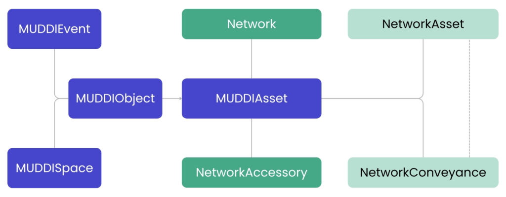
Our engineers played a significant role in establishing the foundation for the platform by developing the client-facing application, middleware services, and DevOps infrastructure required to support a secure, scalable, and reliable system. A major aspect of this work was the development of a data integration and transformation pipeline capable of ingesting utility data from hundreds of providers in various formats, schemas, and quality levels. This pipeline then harmonises the data into a single, standardised model based on the Open Geospatial Consortium’s MUDDI standard. This standardised approach ensures that data from different organisations can be consistently interpreted, visualised and analysed, while providing a scalable foundation for integrating new data providers and enhancing data quality over time.
Source: https://uisltd.substack.com/p/reflections-on-nuar-part-1
Unlike traditional GIS platforms, which simply aggregate source datasets, this platform implements a comprehensive data harmonisation process. Utility data supplied by hundreds of organisations arrives in a variety of formats, schemas and naming conventions, and at varying levels of completeness.
Before the data becomes available to downstream services, it is transformed into a unified representation based on the Open Geospatial Consortium’s Model for Underground Data Definition and Integration standard.
This involves mapping provider-specific schemas to a common data model, standardising feature classifications and attributes, and validating incoming datasets against the target specification. It also involves normalising inconsistencies introduced by legacy data collection practices. Enforcing a common semantic model early in the ingestion pipeline means that downstream components, including map rendering, search, analytics and APIs, can operate on a consistent representation of underground assets, regardless of the original data source.
It also facilitates the onboarding of new utility providers in a scalable manner. Rather than modifying application logic for every new dataset, only the transformation rules need to be extended while the rest of the platform continues to operate using the same standardised data model. This significantly reduces integration complexity and creates a foundation for the systematic assessment of data quality, as well as interoperability and the future evolution of the platform.
We have created a trusted digital model of underground assets, unifying fragmented infrastructure information to provide a single, accessible, consistent view. The result is a platform that helps users make better-informed decisions, reduce operational risks and improve the efficiency of work involving underground networks.
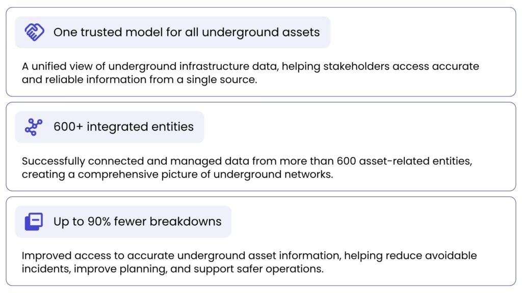
Through our combination of engineering expertise, platform development and close collaboration with Ordnance Survey, we have helped to deliver a critical national capability. This capability makes underground data more discoverable, reliable and valuable for the organisations that rely on it.
Why national underground asset registers matter
Although NUAR is a UK initiative, the challenges it addresses are shared by countries around the world. As infrastructure networks become more interconnected and urban development accelerates, governments require a reliable, standardised overview of what lies beneath the ground. This leads to better decision-making throughout the entire infrastructure lifecycle, from planning and construction to maintenance and emergency response.
Safer excavation & fewer utility strikes
One of the most immediate benefits of a national underground asset register is improved safety. By giving authorised users access to more complete and reliable underground asset information, contractors can plan excavation work with greater confidence, reducing the likelihood of damaging buried infrastructure. Fewer utility strikes. Safer working conditions. Reduced disruption to essential public services.
- Fewer utility strikes.
- Safer working conditions.
- Reduced disruption to essential public services.
Faster planning & delivery
When data is fragmented, planning becomes slow and inefficient. A national register streamlines this process by providing a single, trusted source of underground asset information, helping organisations to:
- reduce the time spent gathering data,
- improve coordination between stakeholders,
- deliver projects more efficiently.
Improved resource management
Better underground asset visibility reduces unnecessary surveys, repeat excavations, and duplicated work, what leads to:
- lower maintenance costs.
- efficient investment decisions.
- long-term asset management.
The UK’s model is gaining attention
As countries invest in digital infrastructure and seek to improve the resilience of critical services, many are encountering the same fundamental issues that initially prompted the development of NUAR. The UK’s experience shows that these challenges cannot be solved by technology alone. Success hinges on a combination of secure data sharing, common data standards, clear governance and collaboration across the entire infrastructure ecosystem.
A reference model for national infrastructure programmes
As NUAR enters its statutory phase in 2026, the UK is transitioning from a successful pilot to the establishment of an underground asset management system as part of its national digital infrastructure. This development is attracting significant international interest from governments and national mapping agencies seeking to modernise their geospatial ecosystems.
Countries and regions exploring similar approaches include:
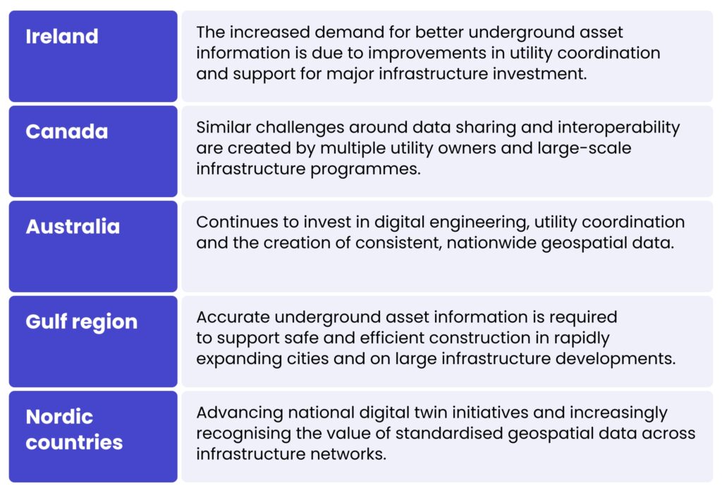
Despite having their own regulatory environments and operational requirements, countries share a common objective – to create trusted, interoperable underground asset data that authorised stakeholders can access securely.
Underground asset registers as national digital infrastructure
Underground asset records were considered operational datasets maintained by individual utility companies. However, governments are increasingly recognising that this information is a strategic national resource.
A comprehensive underground asset register supports far more than just excavation planning. It provides the digital foundation for safer construction and infrastructure maintenance, more efficient infrastructure investment, cross-sector collaboration, improved emergency response, national digital twins, AI-enabled infrastructure planning and more resilient critical infrastructure.
As governments continue to digitise infrastructure and expand national geospatial capabilities, underground asset registers are evolving from standalone mapping initiatives into essential components of national digital infrastructure. In this regard, NUAR serves as a model for how governments can leverage shared geospatial data to deliver safer, smarter, and more resilient infrastructure in the future.
Partner with us to modernise your infrastructure data management
Our team combines geospatial expertise and digital engineering capabilities with experience of delivering national-scale solutions, helping organisations to transform the way they manage underground asset information.
If you are looking to improve utility coordination, enable digital twin initiatives or develop more consistent infrastructure data management approaches, we can help you lay the groundwork for safer, smarter and more efficient infrastructure delivery.
Get in touch to explore how we can support your journey towards connected, and data-driven infrastructure management.
he National Underground Asset Register (NUAR) is a UK initiative which provides a standardised, trusted view of underground infrastructure assets. It consolidates data from hundreds of asset owners on a single, interoperable platform. This allows authorised users to access more comprehensive and reliable information for planning, construction, maintenance and emergency response purposes. NUAR improves safety, efficiency and collaboration across the infrastructure sector.
A national underground asset register mitigates the risks posed by fragmented and incomplete underground utility data. By providing a single source of trusted information, it helps to prevent accidental utility strikes, improve project coordination and support better decision-making. It also minimises delays, repair costs and disruption to essential public services. As infrastructure becomes increasingly complex, reliable underground data is emerging as a strategic national asset.
NUAR uses a data integration and transformation pipeline to harmonise information from hundreds of utility providers. Regardless of the original format, schema or data quality, all datasets are converted into a common model based on the Open Geospatial Consortium’s MUDDI standard. This ensures that data can be consistently interpreted, visualised and analysed across organisations. The standardised approach also simplifies the onboarding of new data providers.
NUAR improves excavation safety by providing contractors with more accurate information about underground assets, thereby reducing the likelihood of them damaging buried infrastructure. It also speeds up the planning process by eliminating the need to gather data from multiple disconnected sources. Better visibility of underground assets reduces the need for unnecessary surveys, repeat excavations and duplicate work. Overall, NUAR supports more efficient project delivery and lower operational costs.
Many countries, including Ireland, Canada, Australia, the Gulf region and the Nordic countries, face the same challenge of fragmented underground asset data. The UK’s experience shows that combining secure data sharing, common standards and effective governance creates a solid basis for managing modern infrastructure. As governments invest in digital infrastructure and national digital twins, systems like NUAR are emerging as a valuable model for the future.


arrow_circle_rightcontact us
Let’s get in touch to check how our experts could support your project

arrow_circle_right our blog