Tech innovations in geospatial software solutions and their impact on the rapid industry growth


In recent years, the geospatial field has witnessed immense growth, fuelled by richer and more precise data and cutting-edge advancements in the digital realm. Constantly emerging technological novelties are continuously contributing to the creation of better-performing and more accessible geospatial software solutions. Consequently, the sector has also begun to play a greater role in developing and supporting other industries.
In this article, we draw from the experience of our experts – Jaroslaw Marciniak (Director of Geospatial Services) and Andrew Radcliffe (Managing Director of Spyrosoft UK), to address the topic of software engineering and technology in the geospatial industry and discover what opportunities they can bring to different companies.
Look at the geospatial industry
Globally, the geospatial industry is growing rapidly. Lately, it has been shifting away from a product-centric approach and focusing on being solutions-oriented with a strong emphasis on IT technologies and engineering. Moreover, advanced geospatial analytics has become integral to various sectors such as archaeology, disaster response, urban planning, infrastructure, logistics, transport and retail.
With that in mind, the prediction given in the GEOBUIZ 2022 Report that the global geospatial market will reach a staggering USD 681 billion by 2025 should come as no surprise. The current growth of the sector is primarily driven by physical technology innovation. With a 45% market share, GNSS & Positioning hardware is predicted to be the most popular and fastest-growing geospatial tech category. It is followed by GIS & Spatial Analytics at 25% and Earth Observation at 17%.
Leveraging geospatial software solutions
Significant innovation opportunities for the market are also offered by software solutions that use location-based data. Workflow integration, image analysis and the extension of spatial analytics into business processes are also important factors contributing to market growth. All of these opportunities pave the way for new geospatial software solutions that utilise location data in various areas, including infrastructure, transport, housing, environment, public health, emergency response, ocean economy, retail and finance.
Professional geospatial service providers
Given the industry’s rapid expansion and its potential to benefit multiple sectors, it’s crucial to explore the market for professional geospatial service providers. Such companies can be categorised as:
- Consulting firms – which typically have experts in the field on staff that offer professional advice and guidance as well as practical solutions.
- GIS software vendors – which are mostly producing software that offer geospatial analysis tools and solutions connected to GIS.
- Technology solutions companies – which deliver hardware-based solutions that are usually used for aerial mapping, GIS/GNSS, UAVs/drones, laser scanning, LiDAR, and more.
- Generic software/platform engineering organisations – which offer geospatial software solutions without having a thorough understanding of the sector, its standards, and the nuances of things like raster data processing, projections, reference systems or various data sources.
For optimal results in a geospatial project, it is advisable to work with companies that specialise in several areas simultaneously. The blending and parallel incorporation of aspects like industry expertise, domain knowledge, technical know-how, advisory services, and business outlook enables a project’s end-to-end coverage and thereby facilitates its completion.

Technology trends in geospatial
The significance of technology in the geospatial industry cannot be overlooked. Innovations in this field can address socio-economic challenges and promote sustainable practices. The use of modern geospatial software solutions can significantly facilitate understanding of some pressing problems and help find answers to them.
According to Gartner’s “2023 CEO and Senior Business Executive Survey“, the technology that will lead the innovation is AI. It will be followed by digitalisation, automation, data analytics, and cloud computing, all of which will significantly impact multiple industries in the coming years.
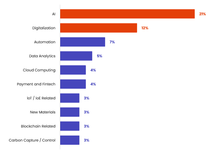
Source: 2023 Gartner CEO and Senior Business Executive Survey
All the mentioned technologies can be used in domain-specific geospatial software solutions. Regarding the main technologies listed above, application examples include:
AI
- Automated feature extraction
- Automated feature attribution
- Objects detection and classification
Digitalisation
- Digital twins – real-world object models
- Hyper resolution algorithms
- Automated generalisation
Process automation
- RPA/Low-code/No-code Solutions
- DevOps practices and IaaC
Data analytics
- Point cloud processing
- Data harmonisation
- Spatial analysis
- Data predictive analysis
- Spatio-temporal analysis
Cloud computing
- Cloud-native
- Edge computing
- Cloud cost optimisation
The Gartner survey also demonstrates that IT functions in businesses should fuel innovation, digital transformation, and front-end experience, which are key activities often strongly linked to business development itself. It is an easily noticeable industry change in which we see IT operations becoming one of the most important centres of growth and innovation, not just a cost centre.
Building advantages with technology and software engineering
At Spyrosoft, we combine technological expertise, domain knowledge, and consultancy skills to help our clients gain digital and business advantages. Our track record includes successful projects involving mobile and web online mapping platforms, backend improvements and incorporating cutting-edge geospatial software solutions that use the technologies like AI and AR/MR.
Apart from that, we meet clients’ needs by designing and implementing data platforms from scratch or conducting integrations with already existing systems. When creating projects, we use microservices-based architecture, UI/UX, agile methodologies and AWS geospatial cloud services.
Over to you
Explore our wide range of projects and discover how Spyrosoft’s experts can help your company build superior geospatial software solutions.
Visit our offering page for more details, or get in touch with us via the contact form below.


arrow_circle_rightContact us
Get in touch and see how we can help

arrow_circle_right Our articles