Strategies to conquer GIS implementation challenges in spatial development


The Geographic Information Systems (GIS) has become an indispensable tool in spatial development, empowering organisations to analyse, interpret, and visualise geospatial data for informed decision-making. With its vast potential for growth and innovation, the global GIS market was valued at $10.24 billion in 2022 and is expected to expand significantly, reaching $23.37 billion by 2029.
However, despite its benefits, GIS implementation often faces challenges such as data interoperability or even limited technical expertise. GIS technologies are sophisticated and require specialised skills to operate effectively. Let’s take a look into GIS implementation challenges and actionable strategies to overcome them.
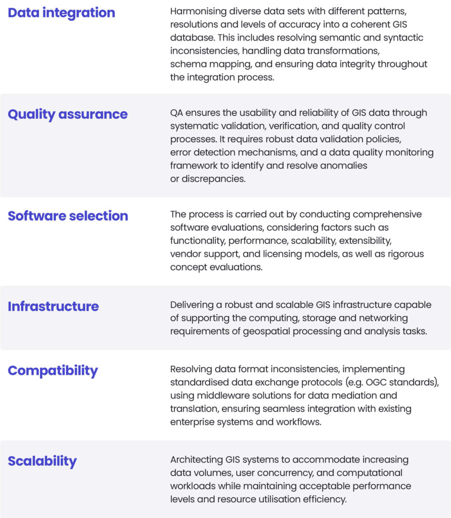
What are the GIS implementation challenges?
As we all know GIS connects data from different sources, such as map tiles, satellite imagery and databases, to analyse and visualise spatial information. It processes geographic data to create maps, identify patterns and make informed decisions.
Implementing this system can be a complex process, fraught with technical challenges that can impact the successful implementation and use of spatial data and analysis tools. These difficulties arise from the nature of GIS technology and its integration into existing workflows and organisational structures. The multidisciplinary character of GIS requires collaboration between different departments and stakeholders, further complicating the implementation process. In addition, spatial data combined with evolving technological advances, adds another layer of complexity, so careful planning and ongoing evaluation are essential to overcome challenges and ensure the successful adoption and use of GIS.
GIS implementation challenges
At Spyrosoft, we specialise in addressing the top challenges associated with GIS implementation. Our team of industry experts offers geospatial consulting services to guide you through all the complexities and benefits of spatial data and analysis tools for your organisation’s success.
Our proven strategies for GIS implementation challenges
We leverage geospatial tools to develop and implement GeoIT solutions tailored to our clients’ specific needs. Drawing upon years of experience and expertise, we have formulated multiple strategies to effectively address the challenges associated with GIS implementation.
Our team of experienced specialists prioritise establishing transparent communication channels to keep all stakeholders informed and engaged throughout the whole GIS implementation process. This strategy ensures that everyone is well-informed, valued, and involved, fostering collaboration, managing expectations, and effectively addressing concerns.
At the forefront of our GIS implementation strategy is the integration of geospatial AI technologies. This approach allows us to leverage the potential of spatial analysis and artificial intelligence, significantly enhancing the efficiency of processing extensive geospatial datasets. By automating feature extraction, classification, and predictive modelling tasks, GeoAI optimises workflows, facilitates decision-making, and enhances the extraction of insights from geospatial data.
Interested in the correlation between GIS and AI?
Read our article
At Spyrosoft, we understand the role of data accuracy or reliability and institute stringent quality assurance protocols to ensure the GIS system functions with high-quality data inputs. This practice reduces the incidence of errors and enhances overall system integrity. Recognising the importance of interoperability, we focus on seamlessly integrating GIS systems with existing organisational infrastructures. This promotes smooth data flow, reduces redundancies, and maximises the platform’s utility within the organisational context. We also employ a strategic approach to resource allocation, ensuring that key resources are efficiently deployed to optimise utilisation, which is both effective and cost-efficient.
In addition, security is paramount to us when it comes to GIS-related projects. That is why we implement comprehensive security measures to protect sensitive data, prevent unauthorised access, and mitigate cyber threats, thereby safeguarding the integrity and confidentiality of GIS information.
Navigating the complexities of GIS implementation requires a proactive attitude towards interoperability, data quality assurance and user empowerment. By fostering a culture of continuous learning and innovation, organisations can harness the full potential of geospatial technologies to address challenges and drive inclusive growth.
Jaroslaw Marciniak, Director of Geospatial Services
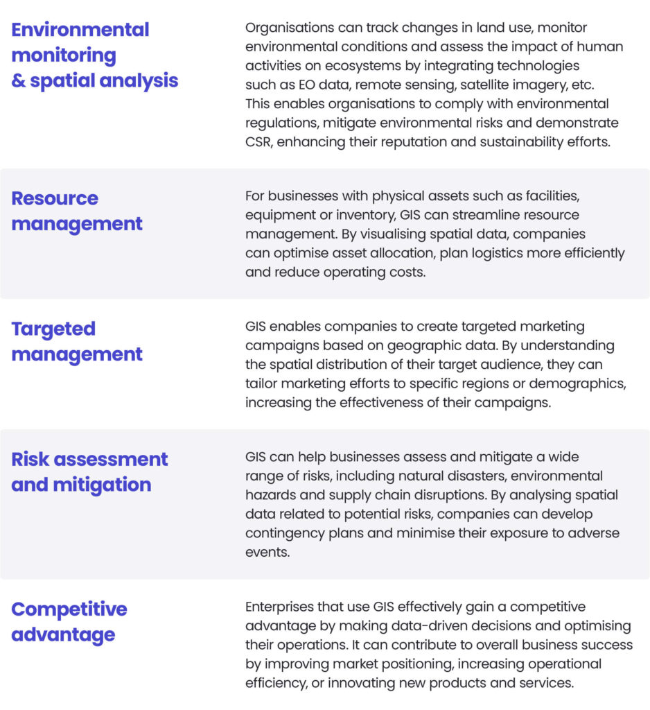
Chances for businesses
GIS implementation can significantly improve various aspects of a business, depending on the industry and the organisation’s specific needs.
Spyrosoft’s successful GIS implementation
Ordnance Survey (OS) recognised for its GIS, cartography, and data visualisation expertise. Since 2018, our partnership with OS has been pivotal in creating and advancing OS Maps, a robust geospatial data infrastructure tailored to diverse mapping needs.
We worked closely with Ordnance Survey to ideate and implement new functionalities, leveraging cutting-edge technologies and innovative features to enhance the user experience. We introduced AR mode to mobile applications and 3D route visualisations on the web platform. Recognising the complexity of global market dynamics, we designed a robust cloud architecture tailored to meet the needs of users worldwide, empowering it with comprehensive analysis capabilities. Our system is optimised for automated raster and vector data processing, seamlessly merging local and regional insights into a cohesive global solution. TAs we understand that success in the global arena requires navigating legal and technological landscapes, we were able to conduct comprehensive analyses to address these challenges. From managing paywalls to orchestrating application rollouts, we ensured data access and safeguarded data protection policies. Our team also refined backend infrastructure for scalability, optimised application performance for diverse geographic locations and ensured seamless offline functionalities to keep OS Maps at the forefront of digital mapping solutions.
Our commitment extended to providing in-depth analysis of global user support along with recommendations and implementation proposals, including 24/7 support, which ensures that the application remains robust, agile, and responsive to the evolving needs of a global user base.
This project highlights the potential of technology consulting to enable and deliver the strategic expansion of a business.
We are your trusted partner in spatial development
Addressing the challenges of implementing GIS in spatial development requires a multifaceted approach that combines technological knowledge with organisational strategy. By recognising the complexities and adopting proactive strategies, businesses can overcome obstacles and benefit from the potential of GIS.
Take the first step towards overcoming the challenges related to GIS, contact Spyrosoft’s experts today or check out our offer and discover the full potential of spatial development!
GIS implementation involves integrating data from multiple sources, aligning various technologies, and coordinating across departments. The complexity lies in ensuring data interoperability, maintaining accuracy, and adapting workflows to leverage spatial insights effectively.
The main challenges include data interoperability, limited technical expertise, system integration with existing IT infrastructure, and ensuring data quality and security. Organisations also face hurdles in change management and cross-department collaboration during implementation.
Success depends on clear communication between stakeholders, strong data governance, and a well-defined implementation strategy. Partnering with experienced GIS consultants like Spyrosoft helps organisations design scalable, secure, and high-performing systems tailored to their specific needs.
GeoAI combines geospatial data with artificial intelligence to automate feature extraction, classification, and predictive analysis. This integration enhances data processing speed, accuracy, and insight generation, helping organisations make better, data-driven decisions faster.
GIS empowers organisations to make location-based decisions, optimise operations, enhance resource management, and uncover spatial trends. When implemented effectively, it becomes a catalyst for innovation, efficiency, and strategic growth across industries.


arrow_circle_right our articles
Pick your next read


arrow_circle_rightGet in touch
