Accessing high-resolution geospatial data with a modern DaaS platform
For our client, a global provider of street-level imagery, LiDAR, and GIS data extraction services, we developed a modern data-as-a-service platform designed to commercialise, manage, and visualise high-resolution geospatial data at scale. The solution enables customers to browse, preview, order and visualise georeferenced content through an intuitive platform, with seamless delivery in standard GIS-ready formats. By delivering backend services, architecture, UI, and cloud foundations, we created a scalable, future-proof solution that gives full control over geospatial assets and supports ongoing growth.

Technologies
Challenges and business needs
As part of further development strategies, our client decided to develop a DaaS platform that allows customers to browse, order and visualise georeferenced data. The challenge in the project was not only to build a scalable platform that would facilitate the acquisition of large-scale, high-quality data but also to ensure that these data would be delivered in standard geospatial formats, enabling seamless use in GIS tools and third-party platforms such as ESRI ArcGIS.
Key business objectives were:
- Providing digital access to high-value geospatial content.
- Establishing an online storefront to monetise captured geospatial data assets.
- Enabling customers to preview and interact with data via an immersive web viewer.
- Providing standardised data outputs in recognised geospatial formats.
- Ensuring scalability and reliability through a robust cloud infrastructure.
Our responsibilities
Our role in the project consisted of covering multifaceted technologies and strategies, including following Agile best practices, enabling iterative development, and adaptive planning throughout the project lifecycle.
We were initially engaged on a project to deliver the platform and associated services, which evolved into a long-term technology partnership supporting NCTech’s ongoing product development and enhancement initiatives.
The scope of our work included:
1. Project discovery and requirements definition
From the initial phases of this collaboration, we provided domain consultation and technology expertise to the project discovery phase and supported the definition of requirements for the final product. This involved securing key technological know-how, understanding the intricacies of geospatial data management, and aligning them with the user’s needs.
2. Architecture and system planning
Together with NCTech, we meticulously planned the system architecture and UI from the ground up. Spyrosoft contributed to the technical design, applying expertise in microservices-based architecture, user-centric design, and the geospatial domain. Whereas NCTech led the data injection and data processing, as well as provided valuable inputs regarding user workflows, business context, and existing frontend components for visualising the data from a user perspective (e.g. Immersive Viewer). We focused on providing user-friendly components to ensure a seamless experience when using the platform.
Our responsibilities
3. Tackling UI/UX design
We took comprehensive care of the UI/UX layer, starting from wireframe definition to final designs and front-end development. Our focus was on creating intuitive interfaces for both the user and administration modules of the web application, as well as upgrading the existing Immersive Viewer user interface. This work was facilitated by productive collaboration with NCTech’s product team, whose valuable feedback helped ensure platform usability and alignment with the end users.
Our responsibilities
4. Bringing DevOps support
Knowing the importance of a robust cloud infrastructure, we provided initial DevOps support by setting up the AWS cloud environment, implementing essential CI/CD pipelines, and configuring core cloud services. After the initial setup phase, NCTech’s internal team continues ongoing cloud operations, with Spyrosoft providing on-demand support when needed.
5. Cloud platform development
Cloud platform development was one of the core areas of our engagement. Our experienced team designed and delivered the complete backend microservice infrastructure during the first phase of the project, ensuring reliability, security, and efficient data processing.
In subsequent phases, the engagement continued collaboratively with NCtech’s backend team, ensuring effective knowledge sharing and joint implementation of new features.
In addition to providing core backend support for the web application, the solution also enabled efficient data post-processing and smooth integration with NCTech’s processing services, becoming the backbone of the entire DaaS platform.
Our responsibilities
6. Client-facing web portal development
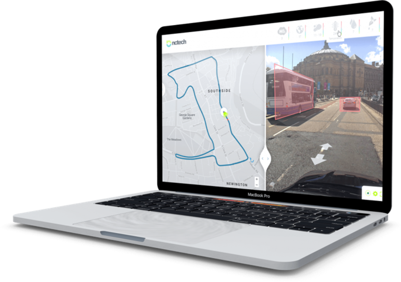
An equally important part of our engagement was frontend development. Our engineers worked closely with NCTech’s technical domain lead to deliver a fully functional geospatial web platform that allows customers to browse, order, and purchase georeferenced data, as well as visualise it through the integrated Immersive Viewer.
To enhance the user experience and analytical capabilities, the platform supports the display of street-level panoramic imagery enriched with point cloud data in a 3D environment, coupled with the classic map-based view. This allows users to seamlessly explore realistic 3D scenes while having spatial context available within a traditional map interface.
Spyrosoft contributed to UI/UX design and backend implementation of elevation visualisation capabilities, aiming to enable the display of elevation levels on the map to assess and highlight areas of potential risk, e.g., such as flooding and water inundation zones. While implementation of the frontend part of this functionality is still in the planning phase, this represents a step toward enhancing advanced spatial analysis and informed decision-making.
To further enhance data analysis and usability, we also implemented functionalities like interactive measurement tools and configurable annotation layers. In addition, our team was involved in developing the administration module, enabling the management of customer and organisation accounts, along with data quality validation, before making datasets available to end users.
Beyond direct support in the development and implementation of the functionalities, Spyrosoft also provided NCTech with PoC demonstrations focused on object detection and classification. These prototypes explored the possibility of using AI/ML models to automatically detect and categorise urban objects such as lamp posts, traffic lights, and road signs. Although the solution ultimately wasn’t included in the application, it demonstrated the potential for further innovation and our ongoing commitment to the client’s project development.
The result
Our collaboration with the client resulted in the successful development and deployment of a modern DaaS platform, empowering businesses to harness the power of end-to-end geospatial solutions. The upgraded platform allows end users to seamlessly view, order, and purchase georeferenced 360 imagery and high-resolution LiDAR data, while ensuring that the acquired data will be available in formats that enable smooth integration with systems such as GIS and ESRI ArcGIS.
By developing the complete web platform and integrating the enhanced Immersive Viewer, we ensured a seamless and intuitive end product for our client’s customers. With our experience in cloud technologies, DevOps, and backend infrastructure maintenance, we provided a comprehensive solution that meets the needs for collecting, processing, and managing high-quality geospatial data.
arrow_circle_right OUR WORK
See other success stories of our clients


arrow_circle_rightContact us
