An introduction to geospatial analysis for business

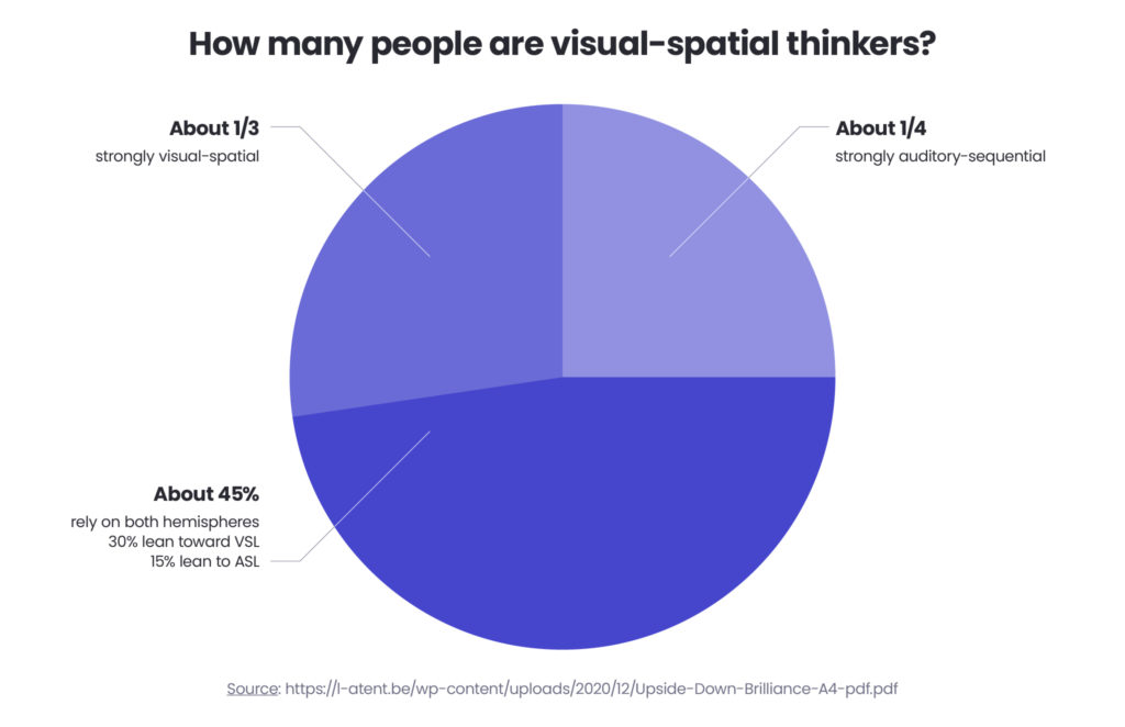
Imagine that you have to get somewhere or explore an unfamiliar area, and instead of a map, you have to follow numeric directions collected in columns and rows – it doesn’t sound too appealing, does it? As humans, a species that has been travelling from day one, we are naturally wired to think visually, in spatial models rather in numbers – the research by psychologist, Linda Kreger Silverman shows that over 70% of people are visual-spatial thinkers.
It’s clear that numbers themselves have never been enough for humans and that’s where Geospatial Analysis comes in. The term itself was coined in the 1960s by a group of Canadian scientists who were documenting the country’s natural resources but has expanded and changed since then, especially with the modern technology available. Right from the start, it was built to echo human perception and its natural way of modelling. Geo-referenced data has become a crucial component, enhancing the understanding of complex relationships between people and locations. That’s how and when GIS (Geographical Information System) was created.
In this article – prepared in collaboration with Spyrosoft’s Principal Data Software Engineer, Michal Lupa, we’ll analyse the current state of Geospatial Analysis, explain what it means now and define how it can help businesses make better decisions and see things from a broader perspective. Location data plays a critical role in geospatial analysis, enabling businesses to optimise store placements, improve logistics, and enhance business intelligence.
What is Geospatial Analysis
Geospatial Analysis is a type of analysis that allows the exploration and discovery of dependencies and common points between the objects within our modelled environment in geographical space. The components of the geospatial analysis are used to provide information on the distance between two objects, the shortest route between them, the condition of the area we monitor, the land relief and elevation of the terrain. By collecting and analysing this data, you can then use it to create a 2D or 3D model of a certain area.
Geospatial Analysis supports the decision-making process in business and in public infrastructure, i.e. to check how ambulances move through a city and if they can reach any area within a designated emergency response time – see below for more use cases.
Distance and directional analysis
A distance and directional analysis focuses on estimating a distance between certain points and is used to calculate the time needed to go from one point to another, either by public transport or a bus. The analysis allows the creation of a temporal coverage map that can be displayed in a public transport/navigation application. This type of analysis is called network analysis and is based on graph techniques including i.e. A* or Dijkstra’s algorithm.

What are the benefits of using Geospatial Data Analytics
Geospatial data analytics offers a wide range of benefits that can significantly enhance an organisation’s capabilities:
Increased efficiency
Geospatial data analytics enables organisations to optimise their operations, reduce costs, and improve productivity. For instance, locational analysis can streamline logistics and transportation routes, saving time and resources.
Enhanced risk management
By identifying areas of high risk through spatial analysis, companies can develop targeted strategies to mitigate those risks. This is particularly valuable in fields like disaster management and environmental conservation.
Making better-informed decisions
When using Geospatial Analysis, you can see the change in your data in space and time which will – in the long run – help you make better-informed decisions. It’s important to mention here that when you deal with Geospatial Analysis, look at the datasets rather than single data points because that will give you a way to track the whole geographical unfolding of a certain event or occurrence.
Enhancing analytics for your employees and customers
As stated above, humans are visual-spatial thinkers, so why not use this principle when designing reports and analyses for your employees and customers? This will make them easier to read and understand.
Enabling the Green Transformation
These geospatial datasets will serve as a starting point for larger projects – this is thanks to the fact that they can be integrated into different tools, including Business Intelligence and Sales Operations products. They can be handily used in any projects related to sustainability and the Green Transformation.
Better customer service
Geospatial data analytics helps organisations understand their customers’ needs and preferences, allowing for more targeted marketing and improved customer service. For example, analysing spatial patterns of consumer behavior can inform retail location strategies and personalised marketing campaigns.
The most popular geospatial analysis software tools
According to Michal Lupa, the businesses that are looking to introduce geospatial analytics products into their projects can now use a vast number of software tools, including:
GIS:
Esri ArcGIS Desktop, ArcGIS Pro – a well-established set of software tools from Esri family used in data processing – from data reading and advanced data analyses to database setup and serving the data as user-friendly web services
QGIS (Open-source GIS tool) – an open-source software that can be used as an alternative to Esri COTS.
Remote sensing:
ENVI, SNAP– used for remote sensing and processing satellite data.
Spatial ETL (Extract, Transform, Load):
FME – used for building ETL pipelines that enable processing data from different sources.
Geokettle – a metadata-driven spatial ETL tool that allows you to integrate data from different sources and then use them to build geodata warehouses, databases and services.
Talend – another ETL tool that you can use for data integration. It provides separate software solutions for data management, data preparation as well as for data and application integration.
Sharing geospatial data:
ArcGIS Server – a backend server component of ArcGIS Enterprise that enables sharing of geoinformation with any application or/and anyone with Internet access. It’s also used to build GIS Web services and platforms.
Geoserver – an open-source alternative to ArcGIS Server.
Mapbox – used for creating beautiful maps that can be then embedded into any website or an application.
Spatial databases:
PostGIS (spatial extension of PostgreSQL) – a powerful geodatabase enabling data processing.
Oracle Spatial – a component of Oracle Database used for creating interactive maps and performing spatial analyses on business data.
SpatiaLite – a PostGIS and Oracle Spatial alternative and a spatial extension to SQLite used for vector geodatabase functionality.
Programming languages:
Python – GDAL, Geopandas, Rasterio – Python libraries allowing for processing geodata.
Arcpy – a Python site-package that enables effective geodata analysis, data conversion and data management.
OpenLayers – an open-source JavaScript library for displaying map data in browsers, similar to Google Maps and Bing Maps.
Esri JavaScript API – an open-source API that allows you to build web applications with 2D and 3D visualisations and interactive maps.
Geospatial analysis techniques and tools
Geospatial techniques and tools can be divided into several categories:
Vector & raster processing tools
These include:
- geometrical processing,
- proximity analysis,
- map algebra,
- geostatistical analysis,
- cartographic design tools.
Remote sensing tools that focus on processing satellite imagery or images captured from airplanes
LiDAR – point cloud processing tools used for creating precise numerical models of a terrain
Network models – graphs that are built to complete distance and directional analyses, including for example bus routes, gas pipelines or water flow through a water supply system.
Geospatial analysis use cases
Due to its flexibility and business value, geospatial analysis can be used in almost any industry and sector, with benefits to its employees, customers, and growth. Here’s a list of the most common use cases.
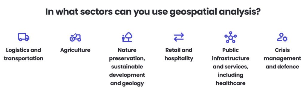
Logistics and transportation
Logistics and transportation are one of the widely used functions of geospatial analytics, and the ones that touch almost every other industry. Not sure how to get somewhere by bus or car? You’d be likely using a tool where advanced geospatial analytics processes will be completed. Planning deliveries for your company and scheduling your production processes around those? You cannot get anywhere without geospatial analysis tools.
Agriculture
Agriculture is one of the sectors that has undergone a massive change over the past 5 – 10 years. While the general public may still see it as an idyllic area where little technology is needed nor used, this is not the case. On the contrary, modern farming entities employ a wide range of digital tools, including robots, AI-based solutions, and last but not least, geospatial analysis products that can easily scan fields for any disturbance to the quality of the crops.
Nature preservation, sustainable development and geology
You can use Geospatial Analysis to model where certain plants or mushrooms would grow, find heatmaps on the city plan, or analyse what minerals could be hidden in a particular rock exposure. Geospatial analysis was first used in this type of project, so it’s a common practice to involve it in any activity related to developing more sustainable environments for both businesses and individuals and those focusing on preserving and hopefully, replenishing any of Earth’s natural resources.
Retail and hospitality
You can check if opening a store, restaurant or hotel in a certain area would be a good idea by simply mapping and analysing the density of service sector facilities in that area.
Public infrastructure and services, including healthcare
You can check if opening a school in a certain area would be a good idea and whether an ambulance would be able to reach certain neighbourhoods.
Crisis management and defence
With the increasing number of natural disasters and occurrences related to the climate crisis, geospatial analysis can play a crucial role in not only managing these, but also as a powerful tool in predicting and preventing catastrophic events from happening.
Over to you
Do you need help implementing geospatial analysis solutions to your business activities? Our Geospatial team is here to help – check our latest offering and get in touch.
About the author
Matylda Chmielewska
Business Researcher
Contact